CHRONOS
Quantifying changing air pollution emissions and atmospheric transport

UNIQUE OBSERVATIONS ADDRESS HIGH-PRIORITY QUESTIONS ON POLLUTANT EMISSIONS & TRANSPORT:
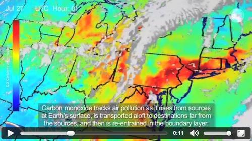
- CHRONOS hourly tropospheric CO and CH4 trace gas observations from GEO will derive pollutant emissions at county scales.
- Simultaneous view of all North America with continuous high measurement density at the city-scale quantifies the impact of changing emissions and transport on regional air quality for science, forecast and management applications.
- Multispectral CO profile retrievals produce near-surface and free tropospheric concentration estimates for investigating pollution in the boundary layer and exchange with the atmosphere above.
- Delivers new capability for continental U.S. CH4 emissions.
Principal Investigator: David P. Edwards
National Center for Atmospheric Research, Boulder, Colorado USA
Investigation Proposed to NASA Earth Venture Instruments-4
CHRONOS capabilities are described in:
Edwards, D. P., H. M. Worden, D. Neil, G. Francis, T. Valle, and A. F. Arellano Jr. (2018), The CHRONOS mission: Capability for sub-hourly synoptic observations of carbon monoxide and methane to quantify emissions and transport of air pollution, Atmos. Meas. Tech., 11, 1061–1085, doi:10.5194/amt-11-1061-2018.
CHRONOS would be the first capability for sub-hourly synoptic observations of carbon monoxide (CO) and methane (CH4) to quantify emissions and transport of air pollution from space.
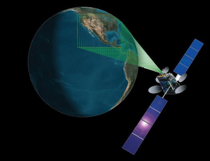
The CHRONOS air pollution observations from geostationary orbit (GEO) are an ideal complement to planned missions because CHRONOS can provide complete synoptic air pollution maps ("snapshots") of the entire continental domain in less than 10 minutes of observations. This rapid mapping enables visualization of air pollution transport simultaneously across the entire North American continent, like weather.
- CHRONOS features strong instrument and science team heritage
- Provides complementary measurements for NASA air quality (TEMPO) and climate (OCO-2) missions
- CHRONOS strengthens the international GEO air quality constellation
- Cost-effective implementation as a commercially hosted payload
Why go to GEO?
Current LEO observations provide a long term global view of atmospheric composition, but there are limitations:
- Coverage is global but sparse: At best 1-2 measurements each day.
- Orbital constraints, persistent clouds further limit sampling.
- Large errors in individual retrievals limit examination of pollutant source and distribution
- variability on diurnal and regional scales.
- Coarse spatial resolution “smears” signatures of local events.
- Significant data averaging is common to produce products.
CHRONOS in GEO provides high density hourly observations:
- Sensor can “stare” to obtain sufficient signal.
- The hourly measurements with 4 km x 4 km spatial resolution significantly increases the probability of cloud-free observations.
- Similar measurement/model scales and continuous near-real-time data delivery will increase uptake of satellite data for regional air quality applications such as chemical weather forecasting and monitoring hazards such as wildfires.
INVESTIGATION OVERVIEW
- The CHRONOS science goal is to characterize the impacts on air quality, climate and energy policy decisions due to changing emissions of methane and other pollutants in North America from urban sources, wetlands, fires and fossil fuel extraction. CHRONOS achieves this urgent goal by measuring methane and carbon monoxide from the perspective of geostationary orbit for the first time, allowing unprecedented temporal and spatial resolution.
- By measuring the key atmospheric pollutants carbon monoxide (CO) and methane (CH4) at high temporal and spatial density from GEO (Geostationary Orbit), CHRONOS quantifies increasing North American emissions with climate impacts, such as from forest fires and energy production, and determines how gaseous pollutants are transported up and away from sources and change downwind air quality.
- The low risk, subsystem high-TRL, gas filter correlation radiometry (GFCR) measurement technique builds on a decade of LEO (Low Earth Orbit) observations from NASA’s Terra/Measurement of Pollution in The Troposphere (MOPITT) mission.
- Investigation implementation through commercial partnerships provides cost-effective access to GEO for a science instrument hosted onboard a communications satellite and leverages existing operations infrastructure.
News
Tracking air quality from high in the sky - October 21, 2015
New satellite observations would significantly improve air pollution forecasts.