News and Status
Terra was launched on December 18, 1999.
Instrument Operations History and Current Status
- On August 11, 2024, MOPITT had a malfunction that disabled the gas cell that is most sensitive to CO in the upper troposphere, above ~600 hPa. MOPITT Near-Real Time (NRT) data production was paused while we investigated the situation. After careful analysis, we determined that the loss of this channel has minimal impact on our retrievals of CO concentrations in the lower troposphere, which rely on a different channel. We have determined that MOPITT NRT is valid for use in that region of the troposphere. After August 12, 2024, measurements reported in the upper troposphere are based on climatology and contain little additional information. The contributions from actual satellite observations relative to climatology are discernable through the reported averaging kernels. The investigation of whether the affected channel can be re-activated is ongoing.
- Upcoming Terra constellation exit in 2022 (see details in announcement below).
- MOPITT recovered from a single event upset on 2019.07.26 that affected the sieve heater for the pressure modulated gas cell used by channel 7. MOPITT science data following this anomaly were degraded. A computer reset was successful in returning the sieve heater to normal operation. We resumed normal science observations on 2019.08.25. MOPITT data acquired between 2019.07.26 and 2019.08.24 should not be used for numerical analysis.
- Timeline of Instrument Status
Science Highlights
- MOPITT data were used to compute trends in carbon monoxide along with co-variation with aerosol optical depth from MODIS. See Buchholz et al., 2021, Remote Sensing of Environment, 256, 112275, doi: 10.1016/j.rse.2020.112275, 2021.
- MOPITT observations over China during the response to the COVID-19 pandemic can be found in the following web article.
- Buchholz et al. published new MOPITT validation results. The study presents the first systematic use of ground-based remote-sensing data from the Network for the Detection of Atmospheric Composition Change (NDACC) to validate satellite-based Measurements of Pollution in the Troposphere (MOPITT) total column carbon monoxide (CO). MOPITT generally shows a small bias relative to the ground-based instruments. The geographic and temporal dependence of validation results are determined. Our findings inform some recommendations for using MOPITT measurements.
- A recent study by Deeter et al. investigates the causes of variability in the information content of MOPITT CO retrievals. The paper demonstrates that both instrumental and geophysical effects yield significant geographical and temporal variability in MOPITT DFS values. An understanding of the geographical and temporal variability of MOPITT retrieval performance is potentially valuable to data users seeking to limit the influence of the a priori through data filtering.
- Seeing Through the Smoky Pall: Observations from a Grim Indonesian Fire Season; news article at NASA Earth Observatory by by Adam Voiland, December 1, 2015.
- A study by Martínez-Alonso et al. reporting the first satellite identification of volcanic CO using MOPITT and IASI products was recently published in GRL and highlighted in Eos Research Spotlight. Only volcanic SO2, HCl, and H2S had been successfully detected from satellites before. Other volcanic markers (elevated MODIS aerosol optical thickness, OMI SO2) were shown to be spatially and temporally co-located with the anomalous CO values and thus confirm their volcanic origin. The volcanic CO concentrations measured by MOPITT and IASI are comparable in magnitude to airborne measurements.
- Long-term trends in CO as observed by MOPITT, IASI, TES and AIRS datasets were recently analyzed in an ACP article by Worden et al. For the period from 2000-2011, they found that all the satellite records are consistent with a modest decreasing trend ∼ −1 % per yr in total column CO over the Northern Hemisphere and a less significant, but still decreasing trend in the Southern Hemisphere. Although decreasing trends in the United States and Europe have been observed from surface CO measurements, they also found a decrease in CO over E. China that has apparently not been reported previously.
Announcements
- August 9, 2021: The MOPITT team announces the release of Version 9 (V9) Level 2 (L2) and Level 3 (L3) TIR-only, NIR-only and TIR-NIR products for the period from March 3, 2000 to March 24, 2021. V9 L2 and L3 products are publicly available through NASA's EarthData portal and by direct download (https://asdc.larc.nasa.gov/data/MOPITT/). 'Beta' products for dates after March 24, 2021 will be available soon. For V9, revisions to the cloud detection algorithm yield substantially improved retrieval coverage for observations over land. The improved coverage should especially benefit studies of (1) regions with persistent clouds and (2) regions commonly affected by severe pollution (with large values of aerosol optical depth). Details of the revised algorithm and supporting case studies are described in Deeter et al., ‘Impacts of MOPITT cloud detection revisions on observation frequency and mapping of highly polluted scenes’, Remote Sens. Env., vol. 262, https://doi.org/10.1016/j.rse.2021.112516, 2021. V9 products also benefit from an improved calibration strategy for MOPITT’s NIR channels. The new NIR calibration strategy results in significantly reduced retrieval bias drift for NIR-only products between annual calibration events. Validation results for the V9 product will be reported in a forthcoming peer-reviewed publication. (Update, Dec. 15, 2021. The V9 validation paper, titled 'The MOPITT Version 9 CO Product: Sampling Enhancements and Validation', has been submitted to Atmospheric Measurement Techniques, and may be accessed at https://doi.org/10.5194/amt-2021-370.)
- Upcoming Terra constellation exit. On February 27, 2020, Terra completed all mission maneuvers related to maintaining a 10:30 mean local time (MLT) equator crossing and 705 km orbit altitude. Terra will begin drifting to an earlier MLT around April 2021. In October 2022, Terra will reach and exceed a 10:15 AM MLT crossing corresponding to a constellation exit with lower orbit altitude (694 km). MLT will continue to drift after this, reaching 9:00 AM around December 2025. After constellation exit, MOPITT science observations will continue in concert with the changing MLT. The major effect will be that the MOPITT surface sampling pattern will no longer be repeating every 16 days. However, sample locations will be reported with the data in the same format as current data. The MOPITT single pixel footprint size will decrease slightly, by 1.5%, as the orbit altitude is lowered from 705 km to 694 km. We do not expect these orbit changes to have significant impacts to MOPITT retrieval quality.
- February 20, 2019: With the recent release of the MOPITT Version 8 Level 2 and Level 3 products, the MOPITT team expects to discontinue production of Version 7 products at the end of 2019. Users who might need Version 7 products for 2020 or beyond should contact the MOPITT team well in advance of this date.
- September 4, 2018: The MOPITT team is releasing Version 8 (V8) Level 2 (L2) retrievals from the Thermal Infrared (TIR) MOPITT channels, with Near-Infrared (NIR), Joint (TIR+NIR) and Level 3 (L3) products coming soon. The primary innovation in V8 is a method to adjust MOPITT Level 1 radiances in order to correct retrieval biases that depend on time and atmospheric water vapor. A temporal bias drift, observed in different vertical layers of the retrieved MOPITT CO profiles when compared to NOAA in situ validation data (Deeter et al., 2017), is likely due to slowly changing parameters within the MOPITT instrument. This bias drift has been sharply reduced and is now within the errors of the validation comparison. The bias dependence on water vapor resulted in retrieval biases that were most pronounced in the tropics and are now are significantly reduced in V8. These improvements to the MOPITT bias drift and latitude-dependent biases should alleviate the need for applying post-retrieval bias corrections to MOPITT CO profiles before data assimilation. In addition, MOPITT V8 uses a consistent MODIS Collection 6.1 cloud mask for the entire data record, includes updated spectroscopic data for water vapor and N2 continua and has improved the method for calculating total column averaging kernels. (Update, December 10, 2018: MOPITT V8 Level 2 and Level 3 products are now publicly available through NASA's EarthData portal and through ASDC's ftp site.)
- April 17, 2017: Re-delivery of corrected data complete. See announcement dated March 23, 2017. V6 and V7 data now available at the LARC DAAC have all been processed using the correct PMC pressures.
- April 3, 2017: Processing and deliveries of the MOPITT Version 6 products will cease on September 20, 2017. Users of V5 and V6 products are encouraged to instead use the V7 products. Please see the V7 User's Guide and errata page for issues in the V6 product that are resolved in V7. In particular, we note that V6N and V6J are not suitable for long term trend analysis. V6 product users who have special needs for V6 products generated for dates after March 31, 2017 should contact the MOPITT/NCAR team and inquire about the availability of such products. V7 validation results are available in: Deeter, M. N., Edwards, D. P., Francis, G. L., Gille, J. C., Martinez-Alonso, S., Worden, H. M., and Sweeney, C.: A Climate-scale Satellite Record for Carbon Monoxide: The MOPITT Version 7 Product, Atmos. Meas. Tech., 10, 2533-2555, https://doi.org/10.5194/amt-10-2533-2017, 2017.
- March 23, 2017: Due to an error in the reported PMC (pressure modulated cell) pressure following the February 2016 calibration activity, it was necessary to reprocess and redeliver MOPITT V6 and V7 data from 2016. Since V7 data are processed with interpolated calibration for the archival product, this required reprocessing for 2015 as well. We are still evaluating the resulting errors in total column and vertical profile CO values, but so far these appear to be relatively small (< 0.5%) and should not affect most users who have already downloaded data from 2015 or 2016.
- March 15, 2017: MOPITT is once again in SCIENCE mode following its yearly calibration activity. MOPITT V7 data taken after 2017.03.15 are considered to be “beta” and are subject to re-processing following the 2018 calibration activity.
- December 2016: Processing and deliveries of the MOPITT Version 5 products will cease on December 31, 2016. Users of V5 products are encouraged to instead use either the V6 or V7 products. V5 product users who have special needs for V5 products generated for dates after December 31, 2016 should contact the MOPITT/NCAR team and inquire about the availability of such products.
- July 2016: MOPITT Version 7 (V7) Level 1 and 2 products are now available for the MOPITT mission from March 2000 to March 2016. Level 3 (L3) product development is in progress and L3 products will be delivered in late summer, 2016. V7 improvements include: (1) radiative transfer modelling now accounts for the growth of atmospheric N2O (an interferent gas in CO spectra) and now uses the HITRAN 2012 data base, (2) improved meteorological fields from MERRA-2 in L2 procesing, (3) improved cloud detection using the MODIS Collection 6 cloud mask consistently over the entire record, (4) optimized radiance bias correction and (5) data record consistency for NIR calibration. More information on the improvements, content and format of the new products can be found in the V7 Data User's Guide (updated July 18, 2017). Archive quality V7 products will only be available after the yearly calibration event (generally in March or April) that allows retrospective processing for the previous year. Generally, V7 Level 2 and Level 3 beta products should become available between three weeks and two months after the actual observations; this data latency is the result of the dependency on the MERRA reanalysis. Beta products are considered un-validated and should not be used for long term trend analysis. Development of near-real time (NRT) data product for MOPITT V7 is in progress and will be announced when available.
- April 2016: Production of MOPITT V5 products has now resumed after a delay in production of the Terra/MODIS Cloud Mask. As explained here, some degradation was observed in the MODIS bands used in the production of the Terra/MODIS cloud mask files after the recent Terra safe mode event. The MODIS cloud mask algorithm was then revised to reduce the effects of instrumental degradation. MOPITT team members then evaluated MOPITT post-safe mode retrievals using both the MODIS Collection 5.1 and Collection 6 cloud masks and found that Collection 6 cloud masks produced the most similar results to pre-safe mode results. Therefore, MOPITT V5 and V6 products for March, 2016 and later will be based on MODIS Collection 6 cloud masks rather than Collection 5.1 cloud masks. To reflect this change, the version identifier in V5 Level 2 filenames has been changed from L2V10.1 to L2V10.2; the version identifier in V6 Level 2 filenames will be changed from L2V16.4 to L2V16.6. MOPITT V7 products, which will be released this summer, will exploit MODIS Collection 6 cloud masks consistently for the entire mission.
- April 2016: MOPITT team scientists have discovered a new source of retrieval bias affecting the V5 and V6 NIR-only and TIR/NIR retrieval products. The effect occurs only in 'forward processing' mode when MOPITT data are processed within a few weeks or months after the actual MOPITT observations are acquired. The effect does not occur in 'retrospective processing' mode when reprocessing data from previous years of the MOPITT mission. Thus, for V5 products, retrieval biases are only evident in NIR-only and TIR/NIR retrieval products for dates after March 26, 2011. For V6 products, retrieval biases are only evident in NIR-only and TIR/NIR retrieval products for dates after March 17, 2012. Retrieval biases result from the fact that 'hot calibration' events used to calibrate the MOPITT NIR radiances only occur approximately once per year. In retrospective processing, information from two calibration events can generally be interpolated, whereas forward-processing NIR calibration relies completely on information from the most recent hot calibration. Gain and offset values based on interpolated calibration data are believed to be more reliable than values based on a single calibration event. Users of affected MOPITT products are warned that the newly discovered source of bias might significantly affect multi-year analyses of CO. This issue will be explicitly addressed in the development of V7 products. For V7, the plan is to release products generated in forward-processing mode as 'beta' products, and to reprocess these data following the next hot calibration.
- March 2016: A recent operational issue with the Terra satellite has interrupted processing of MOPITT Version 5 data products. As documented here, Terra entered 'safe mode' on Feb. 18 during an Inclination Adjustment Maneuver. While in safe mode, all non-essential systems are shut down, and new data are not collected. On Feb. 22, the Terra Flight Operations Team successfully recovered the Terra spacecraft from Safe-Mode back to Normal mode. The MOPITT Instrument team made the decision to conduct the annual hot calibration/decontamination procedure before resuming instrument operations, since this procedure had already been scheduled for the near future. Following this procedure, the MOPITT instrument resumed normal operations on March 3. Therefore, no MOPITT science data were collected between February 18 and March 2. Processing of Version 5 MOPITT Level 2 and Level 3 products will resume again when MODIS cloud mask data again become available; this data product is required as part of MOPITT operational processing.
- January 2016: Only MOPITT observations made in clear sky conditions are processed in Level 2 retrieval processing. The clear/cloudy determination is based both on MOPITT's thermal-channel radiances and the MODIS cloud mask. Since about 2010, degradation in the calibration of one of the thermal-channel bands (Band 29) on the Terra/MODIS instrument (as documented here) has resulted in a false trend towards increasing cloudiness. For MOPITT cloud detection, we have observed that the resulting decrease in the number of valid MOPITT retrievals is mainly evident in tropical nighttime scenes over the ocean. This issue affects both MOPITT Version 5 and Version 6 products, both of which exploit the Terra/MODIS Collection 5.1 cloud mask files. For the MOPITT Version 7 product (now in development), the MOPITT algorithm development team will consider methods for mitigating the problem with the MODIS cloud mask files, possibly including greater reliance on MOPITT's thermal-channel cloud detection.
- January 2016: MOPITT Level 2 retrieval processing requires an external source of meteorological data for temperature and water vapor profiles, and surface skin temperature. The MOPITT Version 6 product has consistently exploited the GMAO MERRA ('Modern-Era Retrospective Analysis For Research And Applications') reanalysis for these required fields. However, that GMAO product has been discontinued and replaced with 'MERRA-2'. Thus, MOPITT V6 products for January 1, 2016 and afterwards will be based on MERRA-2 rather than MERRA. Users will notice a new version number in the MOPITT V6 data filenames to indicate this change. Limited comparisons of MOPITT retrievals processed alternately with MERRA and MERRA-2 have not revealed significant systematic retrieval differences. Thus, we do not expect most MOPITT users to notice any change in the quality of the MOPITT V6 products, but we can not completely rule out that possibility. The MOPITT Version 5 product is not affected by this issue, since V5 processing involves a different source for meteorological fields. The MOPITT Version 7 product (now in development) will be based exclusively on MERRA-2 (until either MERRA-2 is superseded by a new reanalysis product, or MOPITT V7 processing ceases).
- October 2015: The MOPITT Version 7 product is now in development. We anticipate its release in 2016, most likely during the summer. When the V7 product is released, processing of the current Version 5 product will cease. Processing of the Version 6 product will be unaffected. Expected improvements in the V7 product will likely include (1) use of the MERRA-2 reanalysis for meteorological fields used in Level 2 processing (for the entire MOPITT mission), (2) a correction to reduce the impact of occasional calibration anomalies for Channel 5, (3) use of the MODIS Collection 6 cloud mask, (4) explicit representation of the radiative effects of increasing atmospheric concentrations of N2O and (5) an improved method for determining radiance bias correction factors.
- October 2015: MOPITT Version 6 products will soon be affected by a change in retrieval processing. Some time near the end of 2015, it is expected that the production of the MERRA reanalysis (by NASA's Global Modeling and Assimilation Office, or GMAO) will end. Instead, the new MERRA-2 reanalysis will begin to be processed operationally. Some differences between MERRA and MERRA-2 are described here. For MOPITT V6 products, MERRA products are used to generate atmospheric temperature and water vapor profiles corresponding to each MOPITT observation; these profiles are required in the retrieval algorithm. While tests are underway to understand the potential effects of the transition to MERRA-2 on MOPITT V6 products, it is not yet known how significant the effects might be.
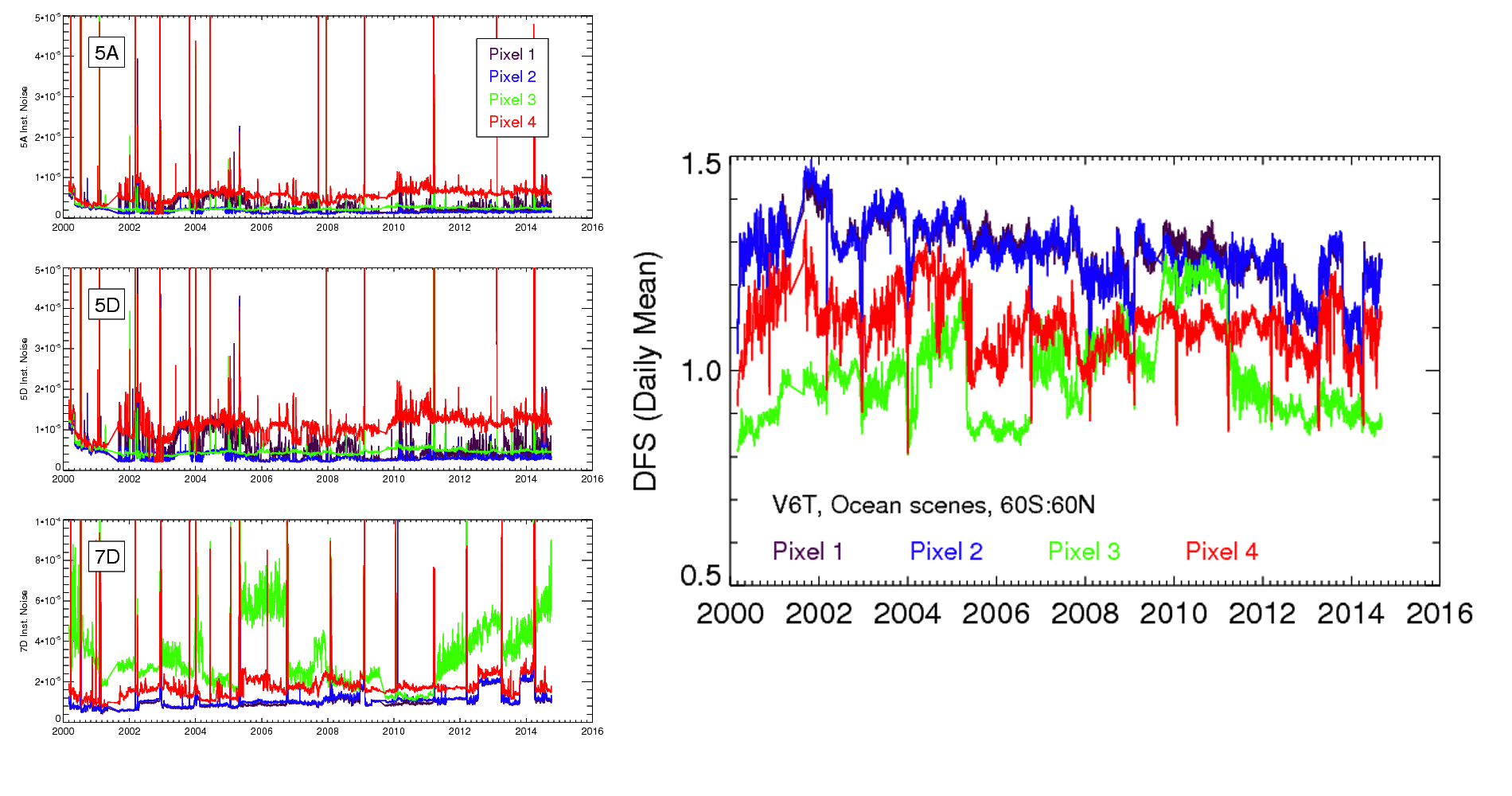
- February 2015: Recent investigations demonstrate that uncertainties in MOPITT radiances (i.e., 'noise') have varied considerably over the mission. This effect has important implications for data filtering strategies and is potentially relevant to all MOPITT data users. In the MOPITT optimal estimation-based retrieval algorithm, Level 1 radiance uncertainties determine the weight given to the measurement for a particular channel. As shown in this timeseries, instrumental radiance errors for the 5A, 5D, and 7D radiances (i.e., the radiances used to derive the Level 2 TIR-only product) vary temporally, but are also different for each of the four detector elements (or 'pixels') which constitute the MOPITT linear detector array. For example, over most of the mission, noise in the 7D radiance was lower for pixels 1 and 2 than for pixels 3 and 4. As a result, DFS values shown in the timeseries plot were significantly higher for pixels 1 and 2 than for pixels 3 and 4 for much of the mission. For data filtering purposes, users can take advantage of the DFS pixel dependence by extracting the 'Swath Index' values in the Level 2 HDF files (included in both V5 and V6 products). See the V5 and V6 User's Guides.
-
September 2013: The Atmospheric Science Data Center (ASDC) at NASA Langley Research Center in collaboration with the MOPITT Science Team is pleased to announce the release of the MOPITT Search and Subset Web Application. Features of the Search and Subset Web Application enable a more efficient approach to selecting and ordering data subsets by supporting spatial, temporal and parameter subsetting for the MOPITT Level 2 Version 5 products. Users can also select data to be downloaded in HDF and NetCDF formats.
The MOPITT Search and Subset Web Application URL: https://subset.larc.nasa.gov/mopitt/login.php
- August 2013: MOPITT Version 6 (V6) Level 1, 2, and 3 products are now available for the entire MOPITT mission. Major enhancements offered in the V6 product include (1) corrected geolocation (latitude and longitude) data, (2) use of the NASA MERRA ('Modern-Era Retrospective Analysis For Research And Applications') reanalysis product for meteorological fields and a priori surface skin temperatures, (3) updated CO a priori and (4) distribution of Level 2 and Level 3 products in HDF5 format. More information on the content and format of the new products can be found in the V6 User's Guide. Generally, V6 Level 2 and Level 3 products should become available between three weeks and two months after the actual observations; this data latency is the result of the dependency on the MERRA reanalysis.
- May 2013: The MOPITT Version 6 Level 2 product is now available for the year 2008. This represents a preliminary release of the V6 product. Features of the V6 product include (1) correction of the geolocation bias in V4 and V5 products, (2) updated a priori based on the CAM-Chem model for 2000-2009, and (3) MERRA reanalysis for temperature and water vapor profiles, and a priori surface temperature. A preliminary User's Guide for the V6 product is available here. As described in the V6 User's Guide, the V6 data products are being released in HDF-EOS5 format and therefore will not be readable with tools developed for previous MOPITT products without significant revisions. Sample IDL code for opening and reading the V6 Level 2 product files is included as an Appendix in the V6 User's guide. While the V6 Level 2 product has been evaluated and is considered technically superior to the V5 product, the MOPITT Algorithm Development Team strongly encourages feedback from the user community with respect to both the content and format of the V6 product. Provided that the feedback is positive, we expect to release the V6 Level 2 and Level 3 products for the entire mission within a few months.
- December 2012: As previously announced, V4 processing will officially end at the end of this month. Processing and deliveries of the V5-TIR, V5-NIR, and V5 TIR/NIR products will continue for the foreseeable future. A manuscript presenting validation results for the V5 products has been submitted to JGR. The V6 product, now in development, will feature: (1) correction of the geolocation bias in V4 and V5 products, (2) updated a priori based on the CAM-Chem model for 2000-2009, and (3) MERRA reanalysis for temperature and water vapor profiles, and a priori surface temperature. Users interested in evaluating the new V6 product prior to the official release should contact Merritt Deeter at mnd@ucar.edu.
- June 2012: Processing and deliveries of MOPITT Version 4 ('V4') Level 1, 2, and 3 products will cease at the end of 2012. The MOPITT V4 product is based solely on thermal infrared (TIR) radiances, and is therefore similar to the newer Version 5 TIR-only product. However, unlike the V4 product, the V5 TIR-only product benefits from (1) explicit modeling of long-term changes in the correlation radiometer gas cells, thus reducing retrieval bias drift, (2) a new method for quantifying radiance uncertainties which accounts for the effects of geophysical noise, and (3) additional diagnostics, such as the retrieval error covariance matrix. Details of these changes can be found in the V5 User's Guide. Current users of the V4 product are encouraged to prepare for this change well in advance. Questions regarding differences between V4 and V5 products should be directed to Merritt Deeter at mnd@ucar.edu.
- April 2012: A small systematic error in the MOPITT geolocation values (latitude and longitude) has been identified. A detailed report analyzing this effect and describing a correction method is available here. This issue affects both current (V4 and V5) and previous (V3) MOPITT operational products. In MOPITT daytime (descending) overpasses, reported longitudes (contained in the Level 1 and Level 2 data files) appear to be systematically biased by approximately 0.35 degrees to the west of MOPITT's actual field of view. Reported latitudes in daytime overpasses do not appear to be significantly biased. The longitudinal error is similar to the size of a single MOPITT field of view (~22 km). Longitudinal errors increase at high latitudes where lines of longitude converge. Geolocation errors for nighttime (ascending) overpasses are different than errors for daytime overpasses.
This data issue should be recognized particularly by researchers applying MOPITT products to study CO concentrations on fine spatial scales (e.g., tens of km). A method for eliminating this geolocation error at the initial stage of data processing is described in this report and will be implemented in the next operational MOPITT product (Version 6). For users of current MOPITT Level 2 and Level 3 products, the geolocation error can be corrected to first order using a latitude-dependent table of zonal-mean geolocation bias values included in this report.
- September 2011: Users of the MOPITT Version 5 (V5) product should be aware of several recent developments.
1. As detailed below, the V5 Level 1 and Level 2 products originally processed for the period March, 2000 - 2009 were affected by several minor processing problems; these products have been reprocessed and have been delivered to the NASA data archives. V5 Level 1 and Level 2 products for 2010 - present have also been delivered to the NASA data archives. New V5 Level 2 products for these two different periods (2000 - 2009 and 2010 - present) have been processed in a consistent manner. This reprocessing does not affect the maturity (e.g., 'provisional' or 'beta') of any of the products.
2. V5 Level 3 products for the entire mission (March, 2000 - present) have been generated and delivered to the NASA data archives.
3. 'Quick-look' daily and monthly images for MOPITT V5 products are now available on the MOPITT website.
Reasons for reprocessing V5 products. The initial production and delivery of MOPITT V5 products covered observations made from March, 2000 through the end of 2009. After delivering the original V5 L1 and L2 products, MOPITT SIPS personnel became aware of several minor processing problems. First, a software module called the 'Post-preprocessor' had been inadvertently disabled. This code implements a minor correction to the Level 0 data for MOPITT's PMC measurements (Channels 3 and 7). Second, the version of MOPFAS used to process the original V5 product for observations during 2009 was based on slightly inaccurate instrument parameters, producing a small radiance bias in Channel 7 radiances. Finally, it was determined that some MOPITT observations (up to several percent each day) were being discarded based on irrelevant instrument parameters. While the MOPITT team believes these technical problems would only concern a small number of MOPITT data users, these issues could conceivably cause larger problems in the future as the instrument slowly degrades. Filenames of the L1 and L2 products include the processing version number and therefore can be used to distinguish the original V5 products and the reprocessed V5 products. The original L1 filenames included the text string 'L1V3.36' whereas the reprocessed L1 files include 'L1V3.37'. The original L2 filenames included the text string 'L2V10.0' whereas the reprocessed L2 files include 'L2V10.1'.
- April 2011: Users of the MOPITT Version 4 (V4) product should be aware of a recent minor instrumental reconfiguration. Because of this issue, the MOPITT L2V8.1 product for March 26-29, 2011, is invalid and has been replaced by the L2V8.2 product.
In October, 2009, one of MOPITT's molecular sieve heaters malfunctioned and became inoperable. Processing algorithms were then revised so that the sieve heater problem did not affect the V4 retrieval products. Following the hot calibration and decontamination performed in mid-March, 2011, this same sieve heater appears to be again functioning normally.
Just as in 2009, data processing algorithms have been revised to account for the slight change in cell pressure resulting from the action of the sieve heater; the consistency of retrieval results before and after the recent hot calibration/decontamination has been verified. Beginning March 26, 2011, the valid MOPITT Version 4 Level 2 product is labeled as L2V8.2 (as in the file MOP02-20110326-L2V8.2.2.prov.hdf). The previous MOPITT product (for the period between October 4, 2009 and March 13, 2011) is labeled L2V8.1.
For a brief period, the L2V8.1 product was generated for MOPITT observations between March 26 and March 29, 2011 and was made available at the DAAC. Any users who might have downloaded the L2V8.1 files for these dates should delete them and replace them with the L2V8.2 product.
- April 2011: The MOPITT V5 product (described below and in the V5 User's Guide) is now available for 2000-2009 through both the NASA ECHO/Reverb system and the ASDC Data Pool.
-
February 2011: The 'Version 5' MOPITT product is now being processed and will become publicly available during the first quarter of 2011. This product will, for the first time, include information from the MOPITT near-infrared (NIR) channels in addition to the thermal-infrared (TIR) channels. As a result, the new 'multispectral' TIR/NIR MOPITT product features improved sensitivity to CO near the surface than the V3 and V4 TIR-based products. (See Worden et al., 2010). The new product also benefits from an improved cloud detection algorithm and is better suited to climate studies than the earlier V3 and V4 products because it exploits a time-dependent radiative transfer model which accounts for long-term instrumental degradation. Processing of the MOPITT V4 product will continue at least until the summer of 2011.
To serve the diverse needs of MOPITT's users, three different products will be generated based on different subsets of the MOPITT observations. Each of these products will be made available as both swath-format Level 2 data and daily and monthly gridded Level 3 data. (Level 3 data products may become available after the L2 data become available.)
The new V5 products will include:- A TIR-only product, similar to the MOPITT V4 product. This product will initially be released as 'provisionally validated.' Compared to V4, this product offers improved long-term stability and more accurately accounts for random errors due to geophysical noise.
- A new NIR-only product, qualitatively similar to the ENVISAT SCIAMACHY CO product. This 'beta' product will be available only for daytime observations over land. Users should be very cautious in using this product, and are encouraged to collaborate with MOPITT science team members to exploit it properly. Compared to earlier TIR-based MOPITT products, this product exhibits larger random errors and may require significant spatial and/or temporal averaging.
- A new multispectral TIR/NIR product, featuring the maximum sensitivity to near-surface CO. In this 'beta' product, information from the NIR channels is limited to daytime observations over land. Users should be very cautious in using this product, and are encouraged to collaborate with MOPITT science team members to exploit it properly. Compared to earlier TIR-based MOPITT products, this product exhibits larger random errors and may require significant spatial and/or temporal averaging.
An update to the MOPITT V4 User's Guide to assist users with the V5 product is being prepared. The V5 HDF files will contain all of the V4 data types in addition to new diagnostics, such as the 'a posteriori' retrieval error covariance matrix and more detailed cloud information. The new V5 products will employ the same 10-level retrieval grid used for V4, but the association between retrieval levels and atmospheric layers has been modified. Specifically, for V5 products, each retrieval 'level' in fact corresponds to a uniformly-weighted layer immediately above that level. For example, the V5 surface-level retrieval product corresponds to the mean volume mixing ratio over the layer between the surface and 900 hPa. Quantitatively, this change may be important when comparing MOPITT products to model output or in-situ data exhibiting strong vertical gradients in the CO profile.
-
January 2010:Near real-time MOPITT L2 and L3 products are being produced near for applications that need faster access to the data than our normal operational products via the ASDC. There are two types of NRT products:
- 2-hour (NRT2): two-hour granule level 2 only products with about a six hour delay from real-time
- daily (NRT): daily level 2 and level 3 products six hours after the last granule is received
Both NRT products use the best GDAS analysis or forecast files available at the time of processing for the ancillary data. They also use only MOPITT cloud detection without MODIS assistance (+- 65 deg latitude cutoff). If collaborators would like access to these files, please contact us.
- October 2009: Near the end of October 3, a backup system employing a molecular sieve to control the pressure in one of MOPITT's Length Modulation Cells (LMCs) became unresponsive. The associated LMC is shared by radiometers for Channels 5 and 6. The apparent failure of the sieve heater led to a weak drop in operating pressure from about 68.5 kPa to 65.3 kPa in a span of about six hours. The effect of this pressure drop on the calibrated radiances and retrieval products was quickly evaluated and the data processing software revised accordingly. Comparisons of data products just before and after the failure of the sieve heater exhibit no observable discontinuities. Since Level 2 data products for the period after the sieve heater failure are not yet fully validated, they are currently labeled as 'provisional' and are identifiable with the string 'L2V8.0.8' in the filename (e.g., 'MOP02-20091004-L2V8.0.8.prov.hdf').
- September 2009: After extensive modeling and analysis of the cooler malfunction, MOPITT was restarted on September 28 with slightly reduced amplitude for the displacer unit on the malfunctioning cooler. Following a cool-down period, science-quality data began flowing again on September 30. Analysis of engineering data, calibrated radiances and retrieval products reveal no measurable degradation of the MOPITT products following MOPITT's idle period between July 28 and September 28. No MOPITT products will be available for this period since the instrument was not operating in science mode.
- July 2009: On July 28, one of the two coolers of the MOPITT instrument developed a malfunction causing the instrument to turn itself off. It was soon determined that no permanent damage had been suffered by the instrument but that operating parameters of the malfunctioning cooler would require some adjustments before the instrument could be returned to operations.
- June 2009: The MOPITT Version 4 product, released as a 'provisional' product in April, is now officially 'validated.' This means that the algorithm used to produce the V4 product is final. V4 validation results will soon be posted on the Data Products page. Users will notice that the Level 2 files now include the string 'val' instead of 'prov' (e.g., 'MOP02-20030303-L2V8.0.2.val.hdf' instead of 'MOP02-20030303-L2V8.0.2.prov.hdf'). Processing of the MOPITT Version 3 product will cease on July 31, 2009.
Users of the V4 product should also obtain the latest revision of the Version 4 User's Guide (updated May 28, 2009) on the Publications page. (Significant revisions include a fuller discussion of array dimensioning issues, and a correction in Appendix 7.4 related to the calculation of the total column averaging kernel.)
- April 2009: The MOPITT Science Team at the National Center of Atmospheric Research announces the availability of the Version 4 product for tropospheric carbon monoxide. This product is currently 'provisional' and is available both from the NASA Langley Data Pool and the ECHO/Reverb system. New Level 2 and Level 3 (gridded) products are available. Users of the new V4 product should obtain the new V4 User's Guide available at the MOPITT website or through the Langley Data Pool. Processing of the current V3 product will cease this summer.
The retrieval algorithm used to generate the V4 product benefits from significant advances in radiative transfer modeling, state vector representation, and a priori statistics. Differences between the V3 and V4 products are generally significant and are detailed in the V4 User's Guide. Retrieval performance has been improved in many respects, particularly in regions of very low and very high CO concentrations. Problems with long-term bias drift are also evidently weaker in V4 than in V3. The new V4 product also includes new diagnostics, including the retrieval averaging kernels.