Validation of TROPOMI carbon monoxide: MOPITT and ATom comparisons
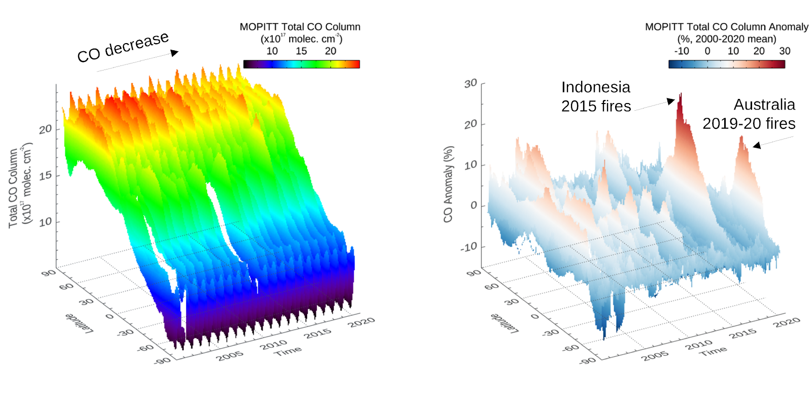
MOPITT (the Measurement Of Pollution In The Troposhere instrument, onboard NASA’s Terra satellite) has been monitoring daily carbon monoxide (CO) since early 2000, providing the longest global tropospheric CO record to date. MOPITT CO retrievals are systematically validated using airborne and ground in situ data. As a result, they represent a consistent and well characterized dataset well suited for climate and ait quality studies (Fig. 1).
As new satellite instruments measuring CO become operational, it is necessary to understand their performance, so the continuity and integrity of the global record is ensured. Martínez-Alonso et al. (2020) analyzed CO retrievals from TROPOMI (the TROPOspheric Monitoring Instrument onboard ESA’s S5P satellite; 2017-present) with respect to MOPITT measurements as well as to vertical airborne profiles from ATom-4 (the fourth campaign of the Atmospheric Tomography mission; April-May 2018). Biases between TROPOMI and the other two datasets were found to be well within TROPOMI’s mission target accuracy of 15%, as summarized in Fig. 2. The standard deviations of the biases were close to the 10% precision target.
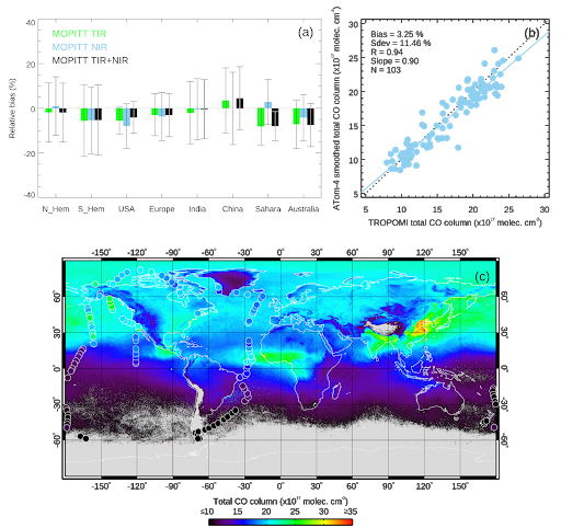
Figure 2. (a) Summary of colocated land comparison results for hemispheric, polluted, and clean regions of interest (November 2017-March 2019). Colored bars show relative bias between TROPOMI and each of the three MOPITT products: TIR (thermal infrared), NIR (near infrared), and TIR+NIR (multispectral). Solid lines indicate the standard deviation of the relative bias. (b) Comparison results for colocated ocean retrievals from TROPOMI and ATom-4 (April–May 2018). (c) Map of averaged TROPOMI CO for the duration of the ATom-4 campaign. Circles show ATom-4 profile locations color-coded according to their total CO column value. There is good agreement between the two datasets, despite differences in the time span and footprint size each of them represents.
TROPOMI and MOPITT were, until TANSO-FTS-2 became operational in 2019, the only working satellite instruments retrieving CO from near infrared (NIR) radiances. Thus, it is important to understand their relative behavior, particularly to extend into the future the unique MOPITT multispectral record (derived from simultaneous measurements in the NIR and TIR, or thermal infrared) using radiances from TROPOMI (NIR) and SNPP-CrIS (TIR), two instruments on satellites flying in loose formation (Fu et al., 2016). Multispectral CO retrievals are particularly relevant because they have in some cases enhanced sensitivity to near-surface CO, where most emissions take place.
References
Fu, D., Bowman, K. W., Worden, H. M., Natraj, V., Worden, J. R., Yu, S., Veefkind, P., Aben, I., Landgraf, J., Strow, L., and Han, Y. (2016). High-resolution tropospheric carbon monoxide profiles retrieved from CrIS and TROPOMI, Atmospheric Measurement Techniques, 9, 2567–2579, https://doi.org/10.5194/amt-9-2567-2016.
Martínez-Alonso, S., Deeter, M., Worden, H., Borsdorff, T., Aben, I., Commane, R., Daube, B., Francis, G., George, M., Landgraf, J., Mao, D., McKain, K., and Wofsy, S. (2020). 1. 5 years of TROPOMI CO measurements: Comparisons to MOPITT and ATom. Atmospheric Measurement Techniques, 13, 4841–4864, doi:10.5194/amt-13-4841-2020.