Satellite sub-grid variability
Sub-grid variability (SGV) in atmospheric trace gases within satellite pixels is a key issue in satellite design and interpretation and validation of retrieval products. However, characterizing this variability is challenging due to the lack of independent high-resolution measurements. We used tropospheric NO2 vertical column (VC) measurements from the Geostationary Trace gas and Aerosol Sensor Optimization (GeoTASO) airborne instrument with a spatial resolution of about 250 m × 250 m to quantify the normalized SGV (i.e., the standard deviation of the sub-grid GeoTASO values within the sampled satellite pixel divided by the mean of the sub-grid GeoTASO values within the same satellite pixel) for different hypothetical satellite pixel sizes over urban regions. The study focused on GeoTASO measurements over the Seoul Metropolitan Area (SMA) and Busan region of South Korea during the 2016 KORUS-AQ field campaign and over the Los Angeles Basin, USA, during the 2017 Student Airborne Research Program (SARP) field campaign. Our analysis showed that the normalized SGV of NO2 VC increases with increasing satellite pixel sizes (from ∼ 10 % for 0.5 km × 0.5 km pixel size to ∼35% for 25km×25km pixel size), and this relationship holds for the three study regions, which are also within the domains of upcoming geostationary satellite air quality missions. We also quantified the temporal variability in the retrieved NO2 VC within the same hypothetical satellite pixels (represented by the difference of retrieved values at two or more different times in a day). For a given satellite pixel size, the temporal variability within the same satellite pixels increases with the sampling time difference over the SMA. For a given small (e.g., ≤ 4 h) sampling time difference within the same satellite pixels, the temporal variability in the retrieved NO2 VC increases with the increasing spatial resolution over the SMA, Busan region, and the Los Angeles Basin.
The results of this study have implications for future satellite design and retrieval interpretation and validation when comparing pixel data with local observations. In addition, the analyses presented in this study are equally applicable in model evaluation when comparing model grid values to local observations. Results from the Weather Research and Forecasting model coupled with Chemistry (WRF-Chem) model indicate that the normalized satellite SGV of tropospheric NO2 VC calculated in this study could serve as an upper bound to the satellite SGV of other species (e.g., CO and SO2) that share common source(s) with NO2 but have relatively longer lifetime.
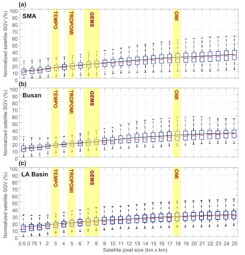
Figure 1. Boxplot (with medians represented by red bars, interquartile ranges between 25th and 75th percentiles represented by blue boxes, and the most extreme data points not considered outliers represented by whiskers) for the normalized satellite sub-grid variability (SGV) over the Seoul Metropolitan Area (a), the Busan region (b), and Los Angeles Basin (c). Normalized satellite SGV is calculated as the standard deviation of the GeoTASO data within the sampled satellite pixel divided by the mean of the GeoTASO data within the sampled satellite pixel. The black lines represent the mean of the normalized satellite SGV at a given size. The resolutions of TEMPO, TROPOMI, GEMS, and OMI are highlighted by the yellow shade in the Figure.
Reference
Tang, W., Edwards, D. P., Emmons, L. K., Worden, H. M., Judd, L. M., Lamsal, L. N., Al-Saadi, J. A., Janz, S. J., Crawford, J. H., Deeter, M. N., Pfister, G., Buchholz, R. R., Gaubert, B., and Nowlan, C. R.: Assessing sub-grid variability within satellite pixels over urban regions using airborne mapping spectrometer measurements, Atmos. Meas. Tech., 14, 4639–4655, https://doi.org/10.5194/amt-14-4639-2021, 2021.