Assessing fine scale variability of urban pollution with aircraft data and the implications for satellite validation and model evaluation
A frequent issue when quantitatively comparing localized ‘point’ measurements of atmospheric composition to larger-scale averages is that the representativeness of the localized measurement at the coarser resolution needs to be assessed. This is a concern when comparing ground-based in-situ or remote sensing measurements with satellite pixel retrievals during validation exercises given typical satellite spatial resolutions of several km. Similarly, there is a concern when comparing localized measurements with model grid values during model evaluation studies. The wider-scale spatial representativeness of a localized trace gas measurement at a given time depends on the regional geography and the heterogeneity of emissions, prevailing meteorology and atmospheric transformations. The temporal representativeness for non-coincident observations depends on source diurnal variation and changing atmospheric mixing as occurs, for example, with the evolution of the planetary boundary layer (PBL) during the day.
The ACOM group working on atmospheric composition prediction has developed statistical measures of pollutant fine-scale spatiotemporal variability based on the uniquely comprehensive coverage of aircraft remote sensing spectrometer measurements taken during airborne field campaigns. The goal here is to make recommendations for assessing representativeness uncertainty of localized measurements for satellite validation and model evaluation. Figure 1 shows Geostationary Trace gas and Aerosol Sensor Optimization (GeoTASO) airborne spectrometer data from KORUS-AQ flights over Seoul, June 9th, 2016, and illustrates how the comprehensive coverage of the spectrometer data captures the significant spatial and temporal variability through the day that is driven by changing emission patterns and vertical and horizontal mixing of pollution.
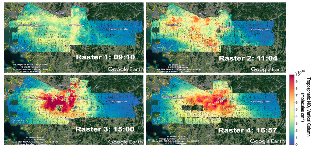
Figure 1. GeoTASO data of NO2 VC (molecules.cm-2) measured during KORUS-AQ over Seoul, South Korea, on June 9th, 2016. The morning and afternoon flights each flew two raster patterns. Local time is indicated for the raster mid-time.
One of the statistical measures that we are using (Tang et al., manuscript for submission to AMT, 2020) to help quantify trace gas variability are spatial structure functions (SSF),
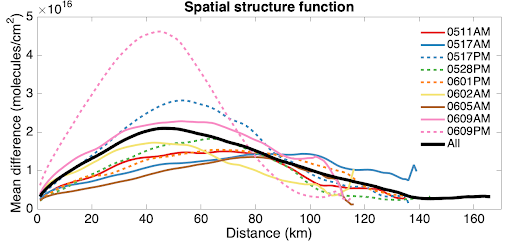
Figure 2. Spatial Structure Function (SSF) for GeoTASO data of NO2 VC (molecules.cm-2) for different flights over the Seoul during KORUS-AQ. SSF for morning flights are shown by solid lines, afternoon flights by dashed lines. Morning and afternoon flights on the same day are shown in the same color. The SSF based on all the data are by the black solid line.